Plate Tectonics and Earth Systems for Grade 6
Grade 6 Earth science asks students to think much bigger in both space and time. Earlier grades focused on weathering, erosion, landforms, and visible surface change. Middle-school science keeps those ideas, but it adds a deeper explanation: Earth’s surface also changes because large plates move over time. That movement can produce mountains, earthquakes, volcanoes, trenches, and other major features. This topic matters because it helps students see Earth as a system rather than a collection of disconnected landforms. Rock patterns, fossil matches, continental shapes, and seafloor structures become evidence that the planet changes over long time periods. Students are not just learning names. They are using evidence to support a major scientific explanation about how Earth works. The strongest instruction treats plate tectonics as an evidence story. Students should examine patterns, ask what those patterns suggest, and then use models carefully. They should understand that Earth’s surface can change quickly in a volcanic eruption or earthquake, but many plate-related changes happen slowly over enormous spans of time.
Earth’s Surface Changes on Different Scales
Some Earth processes are easy to observe in a short time. A river can carry sediment, a landslide can change a slope, and a volcanic eruption can reshape a local landscape quickly. Other changes, such as mountain building or the widening of an ocean basin, happen over much longer times and larger areas.
Students should understand that both short-term and long-term processes matter. Middle-school Earth science becomes stronger when students compare the time scale and size scale of different events instead of thinking all change happens the same way.
This also helps students read evidence more carefully. A sharp change after an earthquake and a broad pattern of matching fossils across continents both tell scientists something about Earth, but they do so on different scales.
Earth’s Outer Layer Is Broken Into Moving Plates
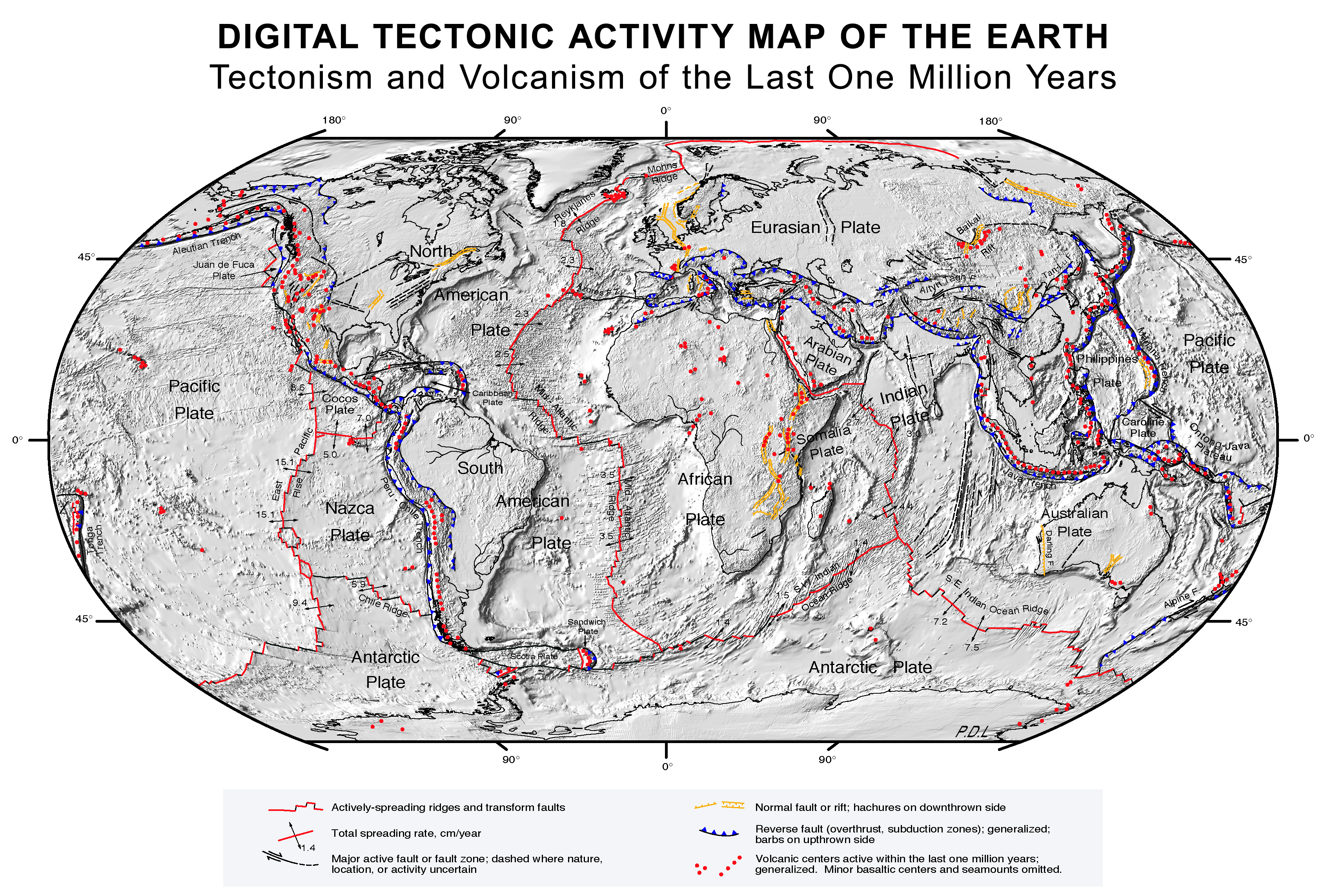
Earth’s outer solid layer is broken into large pieces called tectonic plates. These plates move slowly over the softer material beneath them. Students do not need the deepest geophysics yet, but they should know that the crust and uppermost mantle form rigid plates that interact at boundaries.
When plates move apart, collide, or slide past one another, they can create different surface features. These interactions help explain earthquakes, volcanoes, mountain ranges, and ocean trenches. The plate idea becomes powerful because it gives one connected explanation for many surface patterns.
Students should see that the movement is slow from a human perspective, but still scientifically important. A small amount of movement over a very long time can produce major Earth changes.
Evidence for Plate Motion Comes From Multiple Patterns
Plate tectonics is supported by more than one kind of evidence. Continents look like they could fit together in some places. Matching fossils have been found on continents that are now far apart. Similar rock patterns and mountain belts appear across separated land masses. Seafloor data show ridges, trenches, and age patterns in ocean crust.
Students should understand why this matters. A single clue might be interesting but weak. When many patterns point in the same direction, the explanation becomes stronger. This is a key scientific habit: explanations are supported by multiple lines of evidence.
Students should also practice distinguishing evidence from conclusion. Fossil matches are evidence. Plate motion is the explanation that fits that evidence. This makes scientific reasoning clearer and more disciplined.
Earth’s Layers and Internal Movement Matter
Students should know that Earth has layers, including the crust and mantle, and that internal energy helps drive movement inside the planet. One useful middle-school model is that heat inside Earth contributes to convection-like movement in the mantle, which helps move tectonic plates over time.
This explanation is valuable because it links surface change to internal Earth processes. Mountains, volcanoes, and earthquakes are not random. They are connected to deeper Earth-system movement.
As with all models, the details are simplified at this grade level. Students do not need every advanced mechanism. They do need the big idea that surface features can be explained by a moving Earth system rather than by isolated surface events alone.
Models and Maps Help Scientists Explain a Dynamic Planet
Maps, cross-sections, and physical models help students understand plate tectonics because the full system cannot be watched directly in real time. A map of earthquake locations can reveal boundaries. A cross-section can show the crust, mantle, and subduction zones. A model can demonstrate how different boundary types affect landforms.
Students should also ask what the model is showing well and what it leaves out. A plate-boundary model may exaggerate thickness or speed so that the pattern is easier to see. That is acceptable as long as students understand the purpose of the model.
This is an important scientific habit for Grade 6. Students should not treat a map or model as just a picture. They should read it as evidence and as a reasoning tool. That habit prepares them for harder Earth and environmental science later on.
📝 Key Vocabulary
📐 Standards Alignment
Construct an explanation based on evidence for how geoscience processes have changed Earth’s surface at varying time and spatial scales.
Analyze and interpret data on the distribution of fossils and rocks, continental shapes, and seafloor structures to provide evidence of the past plate motions.
View all Grade 6 Science standards →
🔗 Glossary Connections
⚠️ Common Mistakes to Watch For
- Thinking all Earth-surface changes happen quickly
- Believing continental shape is the only evidence for plate motion
- Confusing the crust with the whole Earth
- Treating models as exact scale copies instead of explanatory tools